LATIN AMERICAN BORDERS ON THE LOOKOUT: RECREATING BORDERS THROUGH ART IN THE MERCOSUL
Excerpt from the text published in the book Placing the Border in Everyday Life, edited by Ashgate Publishers.
“(…)
Marina Camargo’s Tratado de Limites
The 8th Porto Alegre Biennial, which opened its doors in September 2011, was thus very much focused on the local-national dialectic and border issues: they appeared as a paroxysmal expression of complex relations to place. If this came with more intensity in the section curated by Aracy Amaral, “Beyond borders” (Além Fronteiras), where in-situ work was commissioned to local artists of different generations, it is interesting to consider this section alongside the perspective that was taken in the main show. The principal section of the 8th Porto Alegre Biennial, under the title of Geopoetics, presented works dealing with land and space, one of which can be highlighted for its capacity to tie the local and global as well as questioning the borders of identity from a Brazilian point of view. It is called Bandeiras and signed by one of the most famous contemporary visual artists, Emmanuel Nassar. It is interesting to use Bandeiras as an introduction to Marina Camargo’s Tratado de Limites since it stresses the power of national imaginaries in the “continent-country” that Brazil composes, together with the deep anchorage in localities which the size of the nation also imposes. Citizens are easily captured by this local/ national dialectic, now opened to global influences, without really having to experience the national borders which are recalled upon only as symbolic guardians of their territory. Bandeiras consists of a very large display of flags (390 x 540 centimeters), on three walls which encompass the visitor and give him/her an impression of great exoticism, which contrasts with the fact that his/her rational capacities are informing him/her that he/she is probably in front of very banal objects. The work had travelled quite a lot before, since its author drew inspiration from an anthropological exhibition on Ghanaian flags that he visited in Germany in 1993, presented it for the first time in 1998 in Sao Paulo (see also “Como Fiz Bandeiras”, http://artenassar.blogspot.fr). The strength of his contribution is that the 143 colorful pieces that he assembled only present an appearance of territorial identity. They can be immediately identified to flags, the utmost symbol of national belonging, but it is impossible to tag the flags to the country they should refer to because the pieces are not actually country flags. The work presents communal flags from the municipalities of Para, Northern Brazil, the artist’s home region. It was a long and participatory process for him to collect them, since the flags do not normally circulate outside of their communities. E. Nassar had to launch a research campaign in a local newspaper, O Liberal, with the slogan “I want your flag” to be able to account for the diversity of his state. He then assembled them without tagging the names of the places they came from. One could think that his technique of “collage” refers to a traditional representation of hybrid identities in a “mestizo” continent, but he likes to deconstruct this. According to the artist, the flags were also chosen for their colorful diversity, in a pop-art perspective where they become objects of consumption that are denounced by his technique. Only one state of Brazil thus appears as a world of its own, giving place- belonging a fractal dimension that the artist intended to apply at the scale of the federal country or at a global level. The 2011 edition of the work however presents a great difference to the original installation, since E. Nassar does not present the flags themselves but a reproduction of them on painted recycled metal plates. The use of old metal7 to express the identity of a fast developing country is intentionally paradoxical since it materially stresses the “ready-made” component of nationhood that globalization confronts.
The challenge of the section of the 2011 – 8th Mercosul Biennial called “Beyond borders” (Além Fronteiras) resided in the capacity of guest artists to work upon their interpretation of the sense of place which the Rio Grande do Sul provoked. The curator, Aracy Amaral, was able to invite a small group of international artists to the region that hosted the Biennial, offering them good conditions for the creation of an original proposal. She was thus able to travel to the border region three times, first with two fellow invitees, Lucia Koch and Cao Guimaraes, and the third time with Biennial staff who helped her with the logistics of her in-situ performance. This was even more valued by her since she was living in Germany for a long-term residency and thus experiencing the Rio Grande do Sul immersion (a discrepancy which she sees as meaningful, not only because of the material distance it implied). Marina Camargo’s idea of borders is not apparently very explicit, either in the name she gives to her exhibition or in the other documents produced, since she proposes to overcome barriers and scales. However, Marina Camargo’s installations parked off a lot of debate and interest. Not only was her title directly tackling the border issue, but she was also offering a sound and visual device which included photos and video, and even a strange map that visitors were invited to take home as a token of the work.

Figure 3: Marina Camargo, Tratado de Limites, Overview of the installation. Photo credits Fabio del Re, with the permission of the author.
The Tratado dos Limites was based on the documentation of the artist’s immersion in the Pampas region, at the vast plains which join the South of Brazil to Argentina, via most of the Uruguayan territory. Born in Maceió (Alagoas, northeast Brazil) and she moved to Porto Alegre at the age of nine, where she began university, before completing her arts education in Barcelona, New York and Munich: although she had travelled the world, working at the Southern border was also her first opportunity to visit one of her country’s borders. She justifies her decision regarding the location of her piece for the Biennial on the basis of a very personal relationship to this place, both affective and interpretative of what she imagines of international limits: “I chose Pampas, because of special relations for my family, and also of its very vast landscape. I was very impressed on how geography could change the political and the borders: frontiers in this area made no sense, because of the isolation of these areas.”(8) Later in the interview, she told me that she made this choice on the basis of previous visits, but that had never been that exhaustive (“I didn’t cross the area before, I had never crossed them”). The borders located in the Pampa region offered a contradictory appearance, vast plains contrasting with, on some part of their delineation, “rivers make borders,” and according to her, “this is the kind of borders that make sense, not political borders.” So the encounter provoked by the Biennial curator represented a very important turn in her life, both emotionally and professionally: “that work was very special for me: I initiated a different process of work, including more documentation, spending more time on a project.” Its spatial dimensions, between living an enriching professional abroad in Germany and immerging herself into the Pampas borders, have considerably transformed her artistic practices.
This “density of the research” explains the composition of the work finally exhibited, including its title. In the process of documentation of the border area she was about to cross, Marina Camargo visited the Instituto histórico e geográfico do Rio Grande do Sul, the regional historical museum of Porto Alegre, and found there a copy of the treaties that had established the state contours and the international limits of the countries. The opposition of these dry but powerful words with the openness of the landscape was the founding inspiration for her creation. She thus decided to look for a way to convey this complex experience of place through diverted pieces of information (maps, official texts), pictures of what she was discovering, the musical reproduction of the sounds of the wind in the high prairies, together with the making of a border model carved in ice that would melt while being filmed and the documentation of an in-situ performance in Tacuarembó. This plurivocality appears essential to understand her intervention.
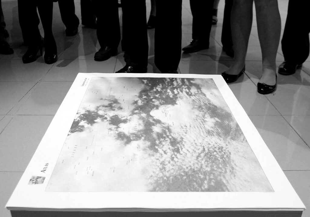
She indeed appeals to the relation between what she was expecting from the border and what upsurges of an apparently very uniform landscape on what hand, as well as to the power of human convention to create diversity and identity in an unforeseen process. Two elements of her installation may appear as the most simple to understand for the visitor: two almost black and white photos which represent a rain curtain over the plains. They were taken near Bagé, where the climate progressively gets very arid—almost desert— and where Marina Camargo was surprised to discover another “kind of invisible frontier, that of climate; there, for some reason, the rain can’t go further, causing the dryness.” They directly answer the “map” that was piled up on the floor in order to be taken away by visitors, where she uses picture of clouds in the sky which shape could be compared to that of continents on a mapa mundi, and she gives life to her oneiric divagation by superimposing a grid of supposed meridians and parallels together with place names as seen in a mirror. The skies reflect our earth and make our dreams of territorial horizons possible. Maps were a very central element of Marina Camargo’s work until her participation to the Mercosul Biennial, linked to her first long sojourn abroad: it is interesting to see here how they are deconstructed: from the Atlas and old maps that she consulted remains only general title for her work, and the take-away document that, according to her words, should work like a tourism office leaflet, has only the appearance of a classic, geospatially referenced, representation.
8a Bienal do Mercosul – Mostra Além Fronteiras, obra de Marina Camargo – 16/09/2011 Visita do Grupo do Congresso de Cardiologia – Foto: Flávia de Quadros/indicefoto.com
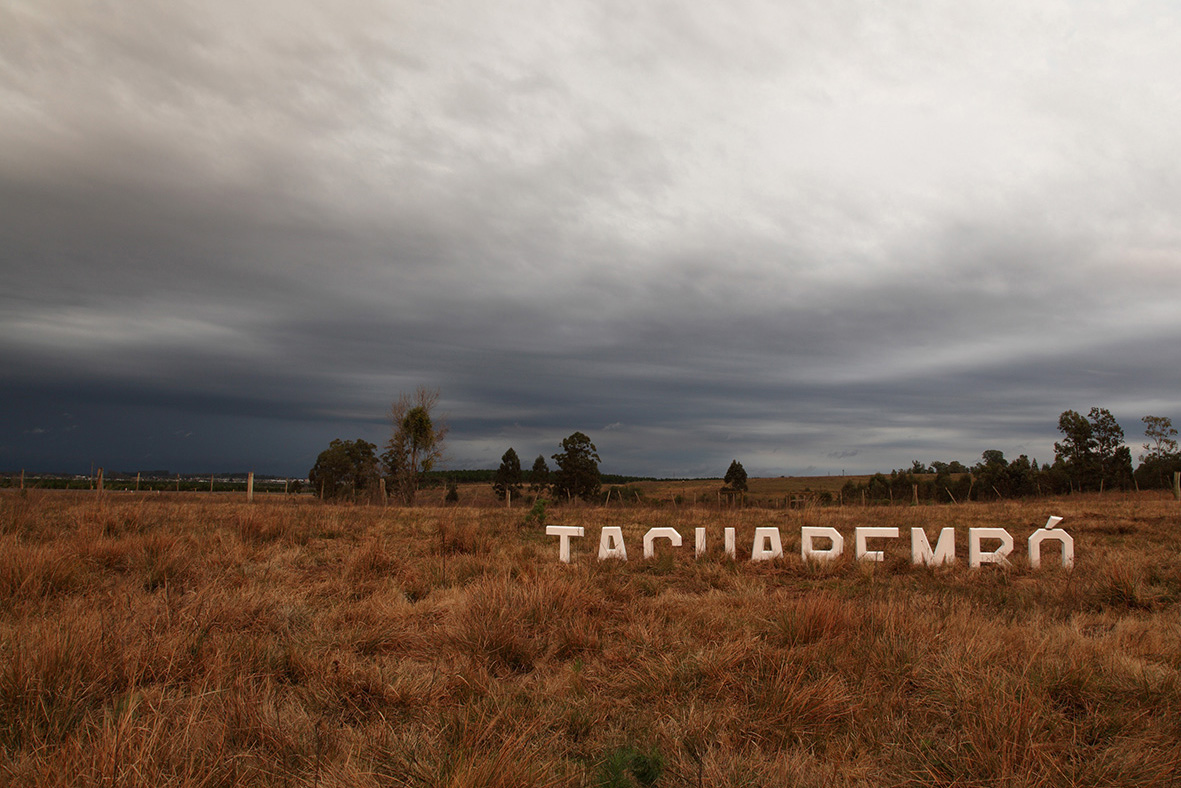
These samples of the region are the most figurative part of her composition. The other very geographic element of her work is more conceptual. It consists of the very condensed documentation of a performance set out in the outskirts of a small town of the Uruguayan part of the Pampas called Tacuarembó. She chose the setting because this small locality has designated itself as the center of this vast region. This quest for centrality in such a landscape may appear as absurd as the border demarcation that straddles it. More precisely, this little town has reformulated its cultural identity as “capital of the Pátria Gaucha”: this process bases itself in the rediscovery of the value of regional belonging when the plains enter the globalized world, which imposed a new intensity to the agri- business in the 1990’s. Whereas “Pampas” is a toponym inherited from the autochthonous languages (“plains” in Quechua), the Gaucho identity bears the weight of the colonial frontier. Marina Camargo decided to make up a replica of the city entrance signs, which she loved to find as she travelled. The material shape it would take was not local but referred to another, world-famous, place name on a hill, that of Hollywood. “There is irony to put those letters in a place that is not important to the world, like Hollywood”: this was the kind of concertinaing that globalization could allow. The fact that micro-locally, the settings where that of a zoo even reinforced the mimicking effect that was intended. She chose the town of Tacuarembó because of its claim to a central position within the region, but she also worked hard to ensure the letters were placed in very precise locations. She insisted on this: “I was also very concerned on how to put this sign there. It was important that it should be buried: maybe it can disappear into the landscape, it can melt down into the landscape when the grass grows” (the process of melting also connects with her ice carving). She therefore envisioned burying the letters that were to be displayed at the entrance to the urban area so that they would little-by-little be incorporated into the vegetative landscape that so fascinated her. But her intervention was looking for a way to interrupt the evenness of the Pampas. In her own way and words, she was “making some point on the landscape ” and, in turn, using the power of demarcation. This was undoubtedly tied to her fascination for maps, and her “concern about how to mark a position in geography.”
The intensity of the performance lies in its power to provoke significant events. In this case, it proved very difficult to bring the letters from Brazil to Uruguay. “But because of this, the work almost did not happen because of the bureaucracy.[…] This is very important information to me: I was somehow provoking the idea of the Biennial title, I was dealing of the limitations of the treaty.” Although the art show was intended to promote the Mercosul regional integration process, its field implementation was bluntly denied. A personal incident also allowed her to measure both the permeability and controlling issues at stake on the border. She recalls, “When I went to Uruguay, I presented my passport, but I didn’t have to do so upon going out, because it was too easy, so when I came back, I had to pay a tax for leaving the country illegally.” Borders were resurfacing where not expected as collective identity building disrupted the personal experience of landscape. That could not be conveyed through images, which is why she worked hard on having a sound track (by Leonardo Boff) that would allow the spectator to feel the wind and its waves, both in the air and in the high weeds.

Figure 5: Marina Camargo, Geografia (Tratado de Limites), 2011, Detail of the melting carved ice Mercosul borders. Photo credits Marina Camargo, with the permission of the author.
The most visually astounding piece of Marina Camargo’s Tratado de Limites, and the one which represents the biggest element of it, is the carved piece of ice with figures a model three dimensions map of the Plata region where the Pampas rivers flow into the ocean. After having sculpted it, she let it melt while regularly photographing it in order to make an animation film, “Geografia (Paisagem com Ondas).”9 The fact that she did not video it also reveals her manner of tackling the relation between trace and process. She recalls that one of her first works was already done with ice, material that offers a “fast way to have a shape becoming another thing or losing its shape”. It questions the way territorialities imply orientation through the various dimensions of space and explore the consequences of their blurring. For her, changing of states between liquid water and ice reflects your feelings when, “for example, you have a text and you lose its meaning, or when you have a map and you have not element to interpret it […]” The progressive disappearance of the sculpture alludes to the frailty of borders. The latter can thus be defined as based on power systems which are enforced by their existence in a self- produced dynamic which a random event could unbalance.
The juxtaposition of these elements is not easy to justify and their authors tries to escape this issue: “I am not very concerned to present a coherent position but I want to approach the closer I can to my ideas.” We cannot totally believe her in those last words since indeed her living of the limits makes up for very profound sensible experience of the kinds of assemblage that define contemporary borders. Marina Camargo’s Tratado de Limites, if intimately rooted into the Rio Grande do Sul’s landscape, still attains a very universal expression of what border work consists of. The contrasts between the visibility and invisibility of the line(s), their multiplicity and uniqueness, the subtle interrelations between crossing and control are all beautifully exposed here.
(…)”
{Text excerpt published on this website with permission of the author and Ashgate Editors}_____________________________________________
7 This is one of his favorite materials, which he had used when featured in a previous exhibition bearing the same name, “Fronteiras”, back in 1997 in his native state of Para (it constituted in the 16th edition of the Arte Para art show). Although most of the works of the show only alluded to the geopolitical component of the title, he had struck it frontally, presenting an installation called Brasil, including a strange map of his country, O Mapa em Negro (1996), featuring the shape of the country in a small red contour painted on a large rusty black metal plate.
8 Personal interview with the artist, ‘skype’ voice and camera conversation, September 16th, 2013. All quotes from this section of the chapter are extracted from the verbatim of this conversation.
9 Visible at: https:/vimeo.com/51392489